Celina FM 455 Project

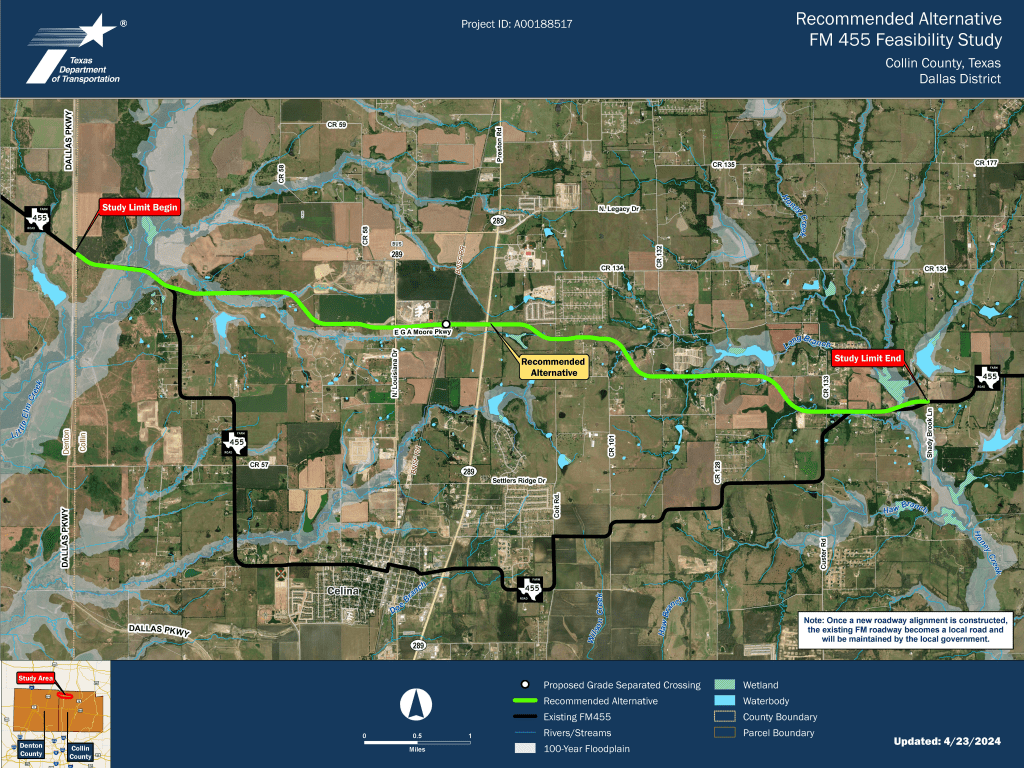
The Texas Department of Transportation (TxDOT) is widening Collin County’s Farm-to-Market Road 455 in a proposed expansion from Dallas Parkway to Shady Brook Lane.  Because the population in Celina, TX has increased by over 26.6% since the year 2000, TxDOT seeks to relieve traffic congestion and inefficient roadways.

The recommended alternative route for the existing FM 455 is 9.2 miles in length and estimated to cost $129 million.  TxDOT seeks to acquire 65 acres, including a total of 81 parcels with 6 residential displacements as the potential result of this project.  The new roadway expansion will be split into two phases: an interim 4-lane roadway as the first installation, and the construction of the 6-lane roadway will conclude the project.  The proposed ROW will vary between 120 ft – 150 ft.  TxDOT will construct turn lanes at intersections and side streets.  The new lanes will be between 11 and 12 feet.

TxDOT states that it opted for a proposed alternative FM 455 route because expanding the existing ROW does not offer flexible expansion prospects and would condemn a larger volume of properties than that of the new route.  TxDOT completed its feasibility study in summer 2024.  TxDOT’s next steps are determined by the schematic and environmental project phase, where TxDOT will likely also determine the new ROW.

Loop 9 Project

The Texas Department of Transportation (TxDOT) is expanding its road infrastructure from east-west US 67 to I-20 in southern Dallas County, northern Ellis County, and part of Kaufman County. This project is known as Loop 9 with an estimated cost of $297 million. Population growth and economic development in the area encouraged TxDOT to conduct feasibility studies that determined the need for road improvements. The Loop 9 project has been divided into three segments – Segment A, Segment B, and Segment C.   

The proposed Segment A project is approximately 9.4 miles in length bounded from US 67 to I-35E. The project will include an eastbound and westbound 3 lane frontage road, a mainline roadway, and a median that would accommodate the future construction of the mainline roadway. Segment A will be built in three phases. TxDOT is proposing to acquire 597 acres of new right-of-way for Segment A.  This includes 56 residential displacements, 3 commercial displacements, and 1 municipal displacement. Construction is to be determined as funding becomes available.

TxDOT began construction on Segment B in January 2022. The project is bounded from I-35E to I-45 and is approximately 12.1 miles in length. TxDOT has acquired all right of way. This segment is being built in four phases. Phase 1 will require approximately three years to construct and is expected to be open to traffic in 2025. The construction of the rest of the phases will be constructed as traffic and funding is available.

Lastly, the proposed Segment C will begin from I-45 and end at I-20. This would be the last segment to be built and is currently inactive.

Project Connect Light Rail in Austin

In November 2020 Austin voters approved an expansion of Austin’s public transit system through a project called Project Connect. When voters approved the project it was estimated to cost $7.1 billion, however, the estimated cost has since risen to $11.6 billion. The Austin Transit Partnership (ATP) has said the increased costs are due to increased labor and material costs, and increased property values for the land needed for expanded right-of-way (ROW). In response to growing costs the designs for the project’s planned light rail lines have been revised. At a public Open House on March 21, 2023, the ATP unveiled five possible design options for the revised light rail system.

All five light rail design options presented propose a significantly smaller system than what was previously planned. The original planned light rail system included two train lines and about 28 miles of track. Of the five new light rail design options, the longest option only includes about 12 miles of track.  Two of the options presented include only street level track, two options include elevated portions of track and street level tracks, a final option includes a small underground section of tract with the rest of the track at street level. All five options propose slightly different routes for the system. The option with the furthest north route stretches to a proposed new North Lamar Transit Center on Lamar Blvd. north of US Hwy 183. The furthest south reaching option stretches to a station on South Congress Ave. near St. Edward’s University. The option that travels the furthest eastward would reach Austin Bergstrom International Airport. None of the options presented would travel further west than North Lamar Blvd. The Austin Transit Partnership did indicate that it views these smaller proposed designs as merely a starter system with the ability to expand any of the options in the future. However, there are currently no proposed future plans for expansion of the system beyond the five design options presented.

All five light rail design options will require an expansion of the ROW along the lines’ routes. Until a final design is chosen it is not possible to determine exactly which properties will be impacted by ROW expansion. The ROW expansion is expected to displace residents and the project’s budget currently dedicates $300 million to displacement issues. It is unknown if the current concerns surrounding the project’s cost will affect this displacement budget. The Austin Transit Partnership is currently taking public feedback on all of the design options and plans to choose a final design in June 2023. ATP expects the earliest the process for acquiring new ROW could being is sometime in 2024, with although ATP stated that the process of taking a few unidentified parcels of land could begin as early as 2023.

I-35 Expansion in Central Austin

The Texas Department of Transportation (TxDOT) will be making improvements to 8 miles of Interstate 35 (I-35) from US 290 East to SH 71 /Ben White Blvd through central Austin in a planned project called I-35 Express Central. According to TxDOT, the project will require 41.7 acres of new right-of-way (ROW) and will result in 107 total displacements, including 69 businesses and 26 residences. Impacted property owners have a constitutional right to be paid just compensation if their land is taken.

TxDOT considered serval build alternatives for the project and has selected Modified Alternative 3 as its preferred alternative. The project’s improvements in Modified Alternative 3 include adding two non-tolled high-occupancy-vehicle (HOV) managed lanes in each direction, lowering sections of the managed and main lanes through downtown Austin, and removal of the existing upper decks between Airport Blvd. and MLK Jr. Blvd. Additional improvements include, adding a boulevard-style frontage road segment through downtown Austin, widened east-west cross-street bridges, reconstructing the bridge across Lady Bird Lake, a new pedestrian/bicycle only bridge, and enhanced bicycle and pedestrian paths.

TxDOT is currently undergoing its environmental review process and expects to release its final environmental report in late summer 2023. Inspections of effected properties by TxDOT’s appraisers have begun. TxDOT currently plans for appraisals and initial offer letters to be sent to landowners in early fall 2023. TxDOT is estimating the first phase of construction will being in spring 2024. The project has an 8-year construction timeline and is not expected to be completed until 2032.

Loop 9 in Dallas and Ellis Counties

The Texas Department of Transportation (TxDOT), through a project known as the Loop 9 Segment A project (CSJ: 2964-10-006), has plans to create a direct east west link between US 67 and IH 35E through Dallas and Ellis counties. The ultimate plan for the project is the construction of a six-lane new frontage road system across the projects 9.4 miles in length. The new location frontage road system would include an eastbound and westbound frontage road facility, each consisting of three 12-foot lanes, an 8-foot inside shoulder, and an 8-foot outside shoulder for bicycle accommodations within the rural section of the proposed roadway, all of which would require new right-of-way (ROW). However after consideration of the limited funding, TxDOT has split the project into two phases; phase 1 would construct a single two-lane, two-way frontage road, and phase 2 would construct the other side of the paired frontage road (if and when funding becomes available).

In March 2022, TxDOT conducted two in-person meetings and one virtual meeting to obtain public opinion and feedback. Currently, there are 4 schematic alternatives as well as 4 modification alternatives. Use the following link to access the project’s interactive map (https://maps.bgeinc.com/Loop9/). According to the timeline they provided, the next steps would be to finalize their environmental impact study by the end of 2023. Right-of-way acquisition is set to begin promptly after that study is complete and approved.

I-35 Improvements in Austin

The Texas Department of Transportation (TxDOT) of Austin will be making improvements to 28 miles of Interstate 35 from SH 45 North to SH 45 southeast though an on-going project known as the I-35 Capital Express Program. It is made up of three stand-alone projects – North, Central and South. The Central project is on a later time frame, while the North and South projects are generally ahead, and on the same timeline.

The North I-35 project’s improvements include, but are not limited to, adding one non-tolled high-occupancy vehicle managed lane in each direction (from SH 45 North to US 290 East), reconstructing bridges, and adding a diverging diamond interchange. TxDOT says that the project will require an additional 17 acres of new right-of-way (ROW), and will displace 5 commercial properties. Offer letters are currently underway and construction is expected to begin sometime this year. Similarly, the South I-35 project’s improvements include, but are not limited to, adding two non-tolled high occupancy vehicle managed lanes in each direction (from SH 71/Ben White Boulevard to SH 45 Southeast), reconstructing bridges, and adding pedestrian and bicycle paths. For the South project, TxDOT says an additional 13 acres of new ROW will be required. Final designs are out, and offers letter are currently being sent to affected landowners. Construction is anticipated to begin in 2022.

US 59 Loop Upgrade

The Texas Department of Transportation (TxDOT) will be widening and reconstructing US 59 in Laredo through the ongoing project known as the US 59 Loop upgrade. The project will be constructed in 3 separate phases; TxDOT has completed the environmental study for phases 1 and 2 of this project. There is a separate ongoing study being done for the 3rd phase of this project. The improvements will take place across a distance of 7.198 miles from International Boulevard to the existing interchange of US 59/SL 20 and BU-59Z. The improvements include six 12-foot wide travel lanes, three 12-foot wide travel lanes, several new overpasses, and much more.

According to TxDOT’s project page, phases 1 and 2 will require approximately 192 acres of new right-of-way (ROW). No residential displacements are anticipated, but 2 commercial displacement are expected.  TxDOT held a virtual public hearing for phases 1 and 2 in April, and are now currently in the process of acquiring the new ROW.  Phase 1, the most rapidly moving of all phase, is set to let for construction in September 2022.

FM 548 in Kaufmann and Rockwall Counties

The Texas Department of Transportation (TxDOT) has proposed a widening and reconstruction of FM 548 within Kaufmann and Rockwall counties. The overall project has been divided into two segments. Segment 1 would expand the current two-lane roadway to a six-lane divided urban minor arterial from US 80 to Windmill Farms Boulevard, and segment 2 would expand the current two-lane rural roadway to a four-lane divided urban arterial (six-lane ultimate) from Windmill Farms Boulevard to SH 205. The existing right-of-way (ROW) width is approximately 100 feet wide while the proposed ROW width is approximately 122 feet wide. The improvements would require approximately 63.4 acres of new ROW and 8.01 acres of proposed permanent drainage easement. According to TxDOT, one vacant non-residential structure will potentially be displaced.  It is estimated that an approximate 115 parcels are to be affected by condemnation. Right of way acquisition is currently underway with construction anticipated to begin in March of 2025.  

The green line displays the limits and route of the proposed project.

SH 105 in San Jacinto, Montgomery, and Liberty Counties

The Texas Department of Transportation (TxDOT) has proposed to reconstruct and widen State Highway (SH) 105 from 10th Street in Conroe to Business 105 in Montgomery, San Jacinto and Liberty counties. The total project cost is estimated to be $175 million and is State and federally funded. The existing SH 105 consists of (generally) a two-lane undivided roadway with 11-foot outside shoulders. The proposed project would include widening to a four-land roadway with a continuous turn land, constructing pedestrian and bicyclist accommodations, and converting the open ditch to curb-and-gutter. The improvements would require approximately 45 acres of additional right of way (ROW). According to TxDOT, displacements of businesses and residences are anticipated. ROW acquisition is currently underway.

Coastal Texas Protection and Restoration

The Coastal Texas Study (conducted by U.S. Army Corps of Engineers (USACE) & Texas General Land Office (GLO)) is a comprehensive plan examining all Texas coastal communities in order to establish coastal storm risk management and ecosystem restoration.  The study began in 2015 and has been gathering and collecting data in its evaluative and analytical phases ever since. That is, until recently when things began picking up speed in the project’s timeline. In April 2021, the Texas legislature passed a bill (SB 1160) that will establish the Gulf Coast Protection District, a regional district with eminent domain powers to decide on taxing and condemnation issues. 

The official Coastal Texas Study website states that “impacts to homes and businesses will be avoided and minimized as much as possible during refinement and optimization of the alignments…voluntary relocations and acquisitions will be pursued, and eminent domain would only be imposed by a local sponsor as a last resort” (Texas Coastal Study, 2021). The Feasibility Report and Environmental Impact Statement (EIS) are being finalized and will be released to the public and submitted to Congress for authorization, funding, and construction in September.