What Austin’s Light Rail Project Means for Property Owners

Austin’s Light Rail Project is moving from planning to property taking. The Austin Transit Partnership (ATP) has already begun taking land, and more property owners can expect to receive survey requests, purchase offers, and other notices as the project moves forward.

The first phase of the project will span nearly 10 miles through North, Downtown, South, and East Austin. To make way for the rail line, stations, and maintenance facility, the project is expected to seize approximately 85 acres, displace dozens of businesses, remove hundreds of on-street parking spaces, and permanently reshape parts of the city.

Light rail development in East Riverside, Austin via Austin American-Statesman

With construction set to begin in 2027, time is of the essence. Austin’s Light Rail Project may lead to reduced property value, lost access, decreased business visibility, parking impacts, relocation costs, and other damages that may not be reflected in ATP’s initial offer. Before accepting an offer or signing any documents, speak with an experienced eminent domain attorney to identify damages that ATP may overlook.

For decades, Marrs, Ellis & Hodge LLP has represented Texas property owners in eminent domain and condemnation matters. If you have received a notice from the Austin Transit Partnership, call (512) 215-4078 today for a free consultation with one of our experienced eminent domain attorneys.

The Howard-Solstice Transmission Line: What You Should Know

A transmission line can cost you far more than the land covered by the easement. If your property is affected by the proposed Howard-Solstice Transmission Line, you could face reduced property value, limits on future development, and damages that may not be reflected in the utility company’s initial offer.

The Howard-Solstice Transmission Line is a proposed 765-kilovolt project that would connect substations near San Antonio and Fort Stockton, crossing 14 counties in South and West Texas. High-voltage electric transmission lines like Howard-Solstice can significantly reduce property values, diminish scenic views and rural character, and disrupt the way of life that you worked hard to build. 

765kV transmission line running through southwest Virginia via Google Maps

This project is now moving quickly. The Public Utility Commission of Texas will soon issue a final route decision. With your property value at stake, now is the time to reach out to an eminent domain attorney.

For decades, Marrs, Ellis & Hodge LLP has represented Texas landowners in eminent domain and condemnation matters. If your property may be affected by the Howard-Solstice Transmission Line, our experienced eminent domain attorneys can help you understand your rights and protect your property. Call (512) 215-4078 for a free consultation today.

Massive New Transmission Lines Are Headed Across Texas

Texas’ first 765-kilovolt transmission lines could permanently reshape the land they cross. If your property falls along the proposed Bell County East to Big Hill or Big Hill Switch to Sand Lake Switch routes, you could face a massive utility easement, imposing transmission towers, reduced property value, and restrictions that may affect your land for generations.

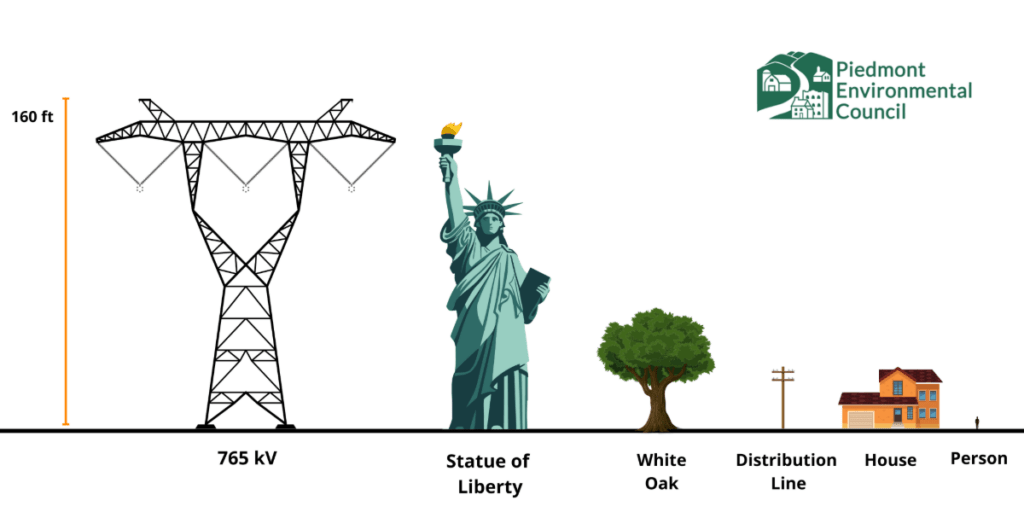
Photo by Piedmont Environmental Council

These will be the first 765 kV transmission lines ever built in Texas, carrying nearly twice the capacity of the state’s existing 345 kV lines. Developed by Oncor Electric Company and the Lower Colorado River Authority Transmission Services Corporation (LCRA), the projects would span more than 390 miles across 25 Texas counties.1 These are 200-foot-wide easements with transmission lines reaching up to 160 feet tall. Projects of this scale can permanently alter your landscape, your property value, restrict future land use, and leave lasting impacts.

The Public Utility Commission of Texas is expected to select the final routes soon. If your property is included, you may begin receiving survey requests, right-of-entry agreements, and easement offers. Before signing any documents or accepting an offer, it’s important that you speak with an experienced eminent domain attorney. 

Marrs, Ellis & Hodge LLP represents Texas landowners in eminent domain and condemnation matters. If your property is affected by the proposed 765 kV transmission lines, we can help evaluate the impact on your land, identify overlooked damages, and ensure you receive fair compensation. Call (512) 215-4078 today for a free consultation.

  1.  The 25 counties being affected include: Bell, Burnet, Concho, Coryell, Crane, Crockett, Ector, Irion, Lampasas, Llano, Mason, McCulloch, Menard, Milam, Mills, Pecos, Reagan, Reeves, San Saba, Schleicher, Tom Green, Upton, Ward, Williamson, and Winkler. ↩︎

Loop 9 Project

The Texas Department of Transportation (TxDOT) is expanding its road infrastructure from east-west US 67 to I-20 in southern Dallas County, northern Ellis County, and part of Kaufman County. This project is known as Loop 9 with an estimated cost of $297 million. Population growth and economic development in the area encouraged TxDOT to conduct feasibility studies that determined the need for road improvements. The Loop 9 project has been divided into three segments – Segment A, Segment B, and Segment C.   

The proposed Segment A project is approximately 9.4 miles in length bounded from US 67 to I-35E. The project will include an eastbound and westbound 3 lane frontage road, a mainline roadway, and a median that would accommodate the future construction of the mainline roadway. Segment A will be built in three phases. TxDOT is proposing to acquire 597 acres of new right-of-way for Segment A.  This includes 56 residential displacements, 3 commercial displacements, and 1 municipal displacement. Construction is to be determined as funding becomes available.

TxDOT began construction on Segment B in January 2022. The project is bounded from I-35E to I-45 and is approximately 12.1 miles in length. TxDOT has acquired all right of way. This segment is being built in four phases. Phase 1 will require approximately three years to construct and is expected to be open to traffic in 2025. The construction of the rest of the phases will be constructed as traffic and funding is available.

Lastly, the proposed Segment C will begin from I-45 and end at I-20. This would be the last segment to be built and is currently inactive.

RM 620 at Anderson Mill Road Intersection Project

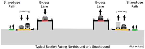
The Texas Department of Transportation (TxDOT) will be making improvements to a 1.2-mile project known as “RM 620 at Anderson Mill Road Intersection Project” from south of Foundation Road to Little Elm Trail, Travis and Williamson counties. It is estimated for construction to cost $45 million. The proposed improvements include the (i) addition of overpasses; (ii) addition of turnarounds; (iii) construction of an additional right-turn lane from northbound RM 620 to eastbound Anderson Mill Road; and (iv) shared-use paths for bicyclists and pedestrians.

Approximately 32 acres of new right-of-way and 0.3 acres of temporary construction easements are required, leading to around 25 commercial displacements. We anticipate right of way acquisition to begin in the next 1-2 months. Appraisers have inspected several property owners’ businesses. Construction is anticipated to start in 2027 according to the TxDOT website. Property owners impacted by this project can seek a free consultation of their case from Marrs Ellis & Hodge LLP.

I-35 Widening in Central Austin

The Texas Department of Transportation (TxDOT) is widening 8 miles of Interstate 35 (I-35) through central Austin from US 290 East to SH 71 / Ben White Boulevard  in a planned project called I-35 Express Central.  According to TxDOT, the project will require 41.7 acres of new right-of-way.

Many of the TxDOT takings will be total in nature (i.e.: TxDOT takes the entire tract of land).  TxDOT reports that the project will result in 107 total displacements, including 69 businesses and 26 residences.  Other takings will be partial, which means TxDOT will take some, but not all, of the property.  Partial takings often damage the value of the remaining land not taken.  

TxDOT has started to issue initial offer letters on certain priority properties. TxDOT will issue more initial offers to other property owners in the coming months. Property owners only get one opportunity to recover the constitutional just compensation owed for the taking. 

If you own property along I-35 that will be impacted by TxDOT’s taking, let the lawyers at Marrs Ellis and Hodge put their experience to work for you.  Contact our Austin office for a free consultation and to learn more about your case, including a courtesy evaluation of any offer you have received.     

US 29/SH 36 Interchange – Central Direct Connect

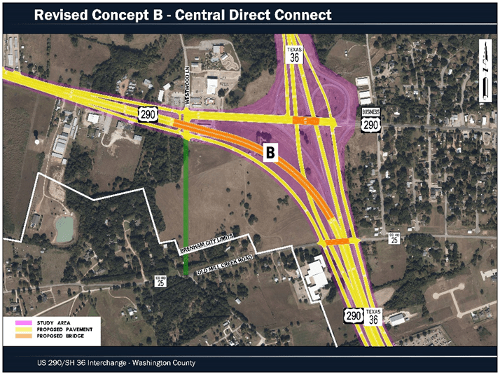
The Texas Department of Transportation (TxDOT) will be making improvements to the intersection of US 290 at SH 36 in Brenham, Texas in a planned project called US 290/SH 36 Interchange – Central Direct Connect. TxDOT originally considered three concepts that were presented and shared with Brenham City Council and Washington County Commissioners Court. Based on feedback from the City and County, TxDOT developed two additional concepts for a total of five concepts. In Spring of 2021, TxDOT announced that Revised Concept B – Central Direct Connect was the selected alternative for further development. All concepts include the following: (i) the expansion of US 290 at SH 36 connection from one to two lanes; (ii) convert frontage roads one-way; (iii) update the entrance and exit ramps to current standards; and (iv) accommodating bicyclists and pedestrians within the urban settings.

TxDOT is anticipating a Public Hearing early 2023. TxDOT is currently undergoing its environmental review process which is an essential part to a finalized route. See the timeline below for anticipated dates of right of way acquisition (expected 2024-2025) and construction start date (expected 2026).

FM 646 in Galveston County

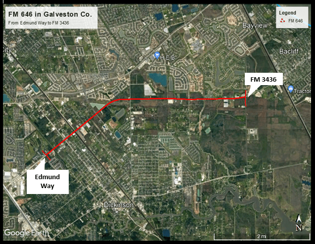
The Texas Department of Transportation (TxDOT) is proposing design modifications and additional right-of-way (ROW) needs along FM 464 from Edmund Way to FM 3436 in Galveston County. The proposed project includes accommodating storm water detention ponds and improving access roadways at the proposed overpass at the railroad crossing.  According to TxDOT’s project page, approximately 20 acres of proposed right-of-way (ROW) will be acquired across the project’s total length of 4.4 miles.  TxDOT hosted a public meeting that was posted as a pre-recorded presentation on Thursday, February 15, 2022. According to that meeting, the next steps would be to update and finalize the environmental studies, design and ROW acquisition.

Widening I-20 in Harrison County 

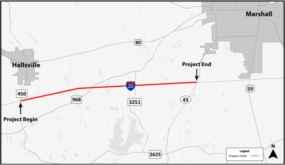
The Texas Department of Transportation (TxDOT) is proposing to widen I-20 in the cities of Hallsville and Marshall from FM 450 to SH 43 (CSJ: 0495-08-109). The project improvements would expand the existing two lanes to three 12-ft lanes in each direction, add one-way frontage roads between FM 450 and FM 3251, and include other mobility improvements. The improvements will run across 10 miles, and require 57 acres of new right of way. Currently, complete funding for the project has not been identified so TxDOT is planning to construct the project in phases. In February, TxDOT conducted an in-person and online public meeting in which they claimed that right of way acquisition is expected to occur from 2023-2026.  According to the project’s development and predicted timeline, the first phase of construction should begin in 2026.

Loop 9 in Dallas and Ellis Counties

The Texas Department of Transportation (TxDOT), through a project known as the Loop 9 Segment A project (CSJ: 2964-10-006), has plans to create a direct east west link between US 67 and IH 35E through Dallas and Ellis counties. The ultimate plan for the project is the construction of a six-lane new frontage road system across the projects 9.4 miles in length. The new location frontage road system would include an eastbound and westbound frontage road facility, each consisting of three 12-foot lanes, an 8-foot inside shoulder, and an 8-foot outside shoulder for bicycle accommodations within the rural section of the proposed roadway, all of which would require new right-of-way (ROW). However after consideration of the limited funding, TxDOT has split the project into two phases; phase 1 would construct a single two-lane, two-way frontage road, and phase 2 would construct the other side of the paired frontage road (if and when funding becomes available).

In March 2022, TxDOT conducted two in-person meetings and one virtual meeting to obtain public opinion and feedback. Currently, there are 4 schematic alternatives as well as 4 modification alternatives. Use the following link to access the project’s interactive map (https://maps.bgeinc.com/Loop9/). According to the timeline they provided, the next steps would be to finalize their environmental impact study by the end of 2023. Right-of-way acquisition is set to begin promptly after that study is complete and approved.